











Google DeepMind and Google Research released WeatherNext on September 3rd. Officials stated that this global weather AI model can directly incorporate data from real-time geosynchronous satellites and meteorological station observations to generate new forecasts hourly, and it has improved the spatial resolution of some surface variables to 5 kilometers. This capability has already been integrated into Google search, Gemini, maps, Google Maps Platform, and Cloud, which means that the research model is now being utilized in the daily decision-making processes of ordinary users and enterprises.
Compared to the previous generation WeatherNext, which generated results with a 25-kilometer grid and a 6-hour time step, the new model offers multiple resolutions: key surface variables such as temperature and humidity can be resolved down to 5 kilometers, other surface variables to about 10 kilometers, and variables like atmospheric wind speed to about 25 kilometers. Google is described as being approximately five times clearer than the previous generation. The term “clearer” here mainly refers to finer time and spatial grids, and does not imply that five times greater accuracy is achieved at every location or under every weather condition.
Real-time observation changed the starting point of the model.
Many AI weather models primarily learn from reanalysis or simulation data generated by numerical weather forecasting systems. These data are rich in physical information but may have a delay of several hours. Rapidly forming rainfall, local temperature changes, and suddenly developing storms are very sensitive to the initial conditions. WeatherNext Models that directly incorporate hourly updated satellite observations are hoped to provide a more accurate representation of the atmospheric state at the current moment.
Satellites cannot observe all variables, therefore the model also incorporates data from sparse weather stations and historical analysis. It uses a unified generative network to map data from different sources and with varying densities onto a global grid, and then outputs results such as temperature, humidity, wind, precipitation probability, and cyclone paths. AI In this context, it does not abandon physical laws; instead, it learns statistical relationships from a large amount of observations and historical trends, and ensures that the outputs are consistent across different scales.
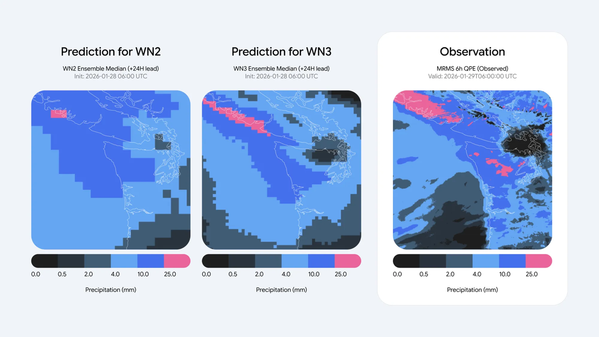
Precipitation is a key focus of this upgrade. Rain and snow are driven by cloud processes that are very small in scale and change rapidly, and global models often predict precipitation boundaries too smoothly. According to Google, the new model uses satellite products from the IMERG global precipitation measurement mission, as well as self-built satellite radar re-analysis data for training. In medium-term global forecast evaluations, the continuous grading probability scores have improved by approximately 60%, 30%, and 10% compared to different baselines, respectively. The specific improvement depends on the reference data and the lead time of the forecast; therefore, the highest figures cannot be generalized to all regions.
A finer grid is particularly important for coastal areas, valleys, and mountainous regions, as the terrain can result in different temperatures, humidity, and precipitation at locations just a few kilometers apart. Details that in the past could only be obtained through expensive regional simulations are now available more quickly through global AI models. However, a resolution of 5 kilometers is still not sufficient to analyze the convective weather for each individual street, and weather forecasts on mobile phone interfaces are also limited by a lack of local sensors and the rarity of extreme events.
From weather apps to energy and supply chains
WeatherNext Three new variables related to clean energy have been added, including wind speed at approximately 100 meters in height, high-resolution cloud cover, and solar radiation. These data correspond to the actual needs of wind turbine hubs and photovoltaic power stations. If grid operators can more accurately estimate the future output of wind and solar power, they will be able to arrange backup power sources, energy storage, and inter-regional transactions more effectively, thereby reducing costs associated with prediction errors.
Agriculture, aviation, logistics, and emergency response will also benefit. Farms need to determine the timing for irrigation and harvesting, airlines need to plan flight routes, and supply chain teams are concerned about port storms and extreme weather. Global forecasts updated hourly can provide more timely information, but high-risk decisions cannot rely solely on a single business model. Alerts from meteorological agencies, radar, ground observations, and professional forecasters remain necessary sources of cross-validation.
Google integrates the model into search, Gemini, and maps, expanding its distribution and also increasing the responsibility for providing explanations. The brief weather forecasts that users see should distinguish between probabilities and confirmed facts, and should indicate the timeliness of the predictions. While the model performs better on average indicators, this does not mean it is more reliable in every extreme event. For risks such as hurricanes, flash floods, and wildfires, the consequences of low-probability errors are far more severe than those of everyday temperature variations.
The scope of deployment is also worth noting. Officials state that the model has been integrated into multiple Google products, but specific features may be rolled out in phases depending on region, language, product interface, and data permissions. When enterprises connect through Cloud, they also need to verify the list of variables, update delays, service levels, and historical backtesting results. The launch of the global model does not mean that every type of professional meteorological data is immediately available at all locations.
Independent evaluation is the next hurdle. Weather models tend to achieve good scores in predicting average weather, but the real test comes from predicting rare heavy precipitation events, rapidly intensifying cyclones, and areas with sparse observations. The research team cited real-time evaluations from Brightband, but users should still wait for comparisons from more meteorological agencies across different seasons and with varying lead times. Only by running the models continuously can we distinguish between the structural advantages of the models and just good luck with weather samples during certain periods.
WeatherNext The "3" in AI represents a shift in weather forecasting from offline competitions to continuous services: more real-time inputs, more frequent outputs, and higher resolution, with integration into energy and mapping products. Whether it can outperform traditional and hybrid systems in the long term will depend on independent real-time evaluations, performance in different regions, and cases of extreme events. The most reasonable expectation is not that AI will replace meteorology, but rather that observations can be converted into usable forecasts more quickly, followed by professional systems and human judgment to determine how to take action.